USGovXML
Content: 


 Usability:


usgovxml.com/mobile/ (HTML5)
usgovxml.com/mobile/ (HTML5)

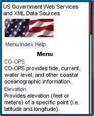
USGovXML usgovxml.com/mobile USGovXML is a collection of mobile mashups based on web and mapping services provided by the US government. There's a huge amount of information available using these tools which include the following services:
- Gazetteer: A geographic dictionary that provides latitude and longitude information for many places throughout the U.S..
- Proximity: Find the distance to the nearest wetland with map.
- Elevation: Provides the elevation of a particular point and a map.
- Station: Shows water quality monitoring stations within a geographic area on a map.
- CO-OPS: Tide, current, water level and other coastal oceanographic information.
- NDFD: Extremely detailed weather forecast data from the National Weather Service’s digital forecast database.
- UV Index: Predicts the next day’s ultraviolet radiation levels.
- Web Tools: Zip code lookup, address verification and the determination of which city is in a particular zip code.
- SBSS: Returns a firm's 8(a), HUB Zone and SDB certification status from the Small Business Administration's database.
The site is optimized for Mobile Internet Explorer but is usable in other full-web mobile web browsers including Opera Mobile and Mini, Webkit and Safari.
