MTR Hong Kong
mtr.com.hk/mobile/eng/index.html (xhtml-mp)
Interactive trip planner for Hong Kong's Mass Transit Railway. Covers all MTR light and heavy rail and bus lines including the Airport Express. The site also has tourist information and information about handicapped access, station facilities and the railway's MTR Club rewards program. Source: Oh! Mobile Directory

NextBus
nxtb.us/mini/index.webui (HTML5)
www.nextbus.com/s/w2 (wml)
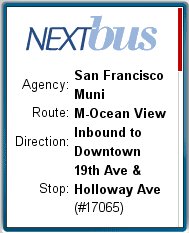
NextBus is an Alameda, California supplier of real time passenger information technology to the transit industry. The technology delivers frequently updated estimates of the arrival time of the next transit vehicle at a given stop. Delivery is by electronic signs, voice response systems and the Internet including the mobile web. NextBus is currently operational on 45 transit systems in the US and Canada.
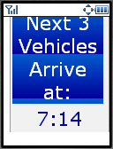
NextBus' real time transit information can be accessed at http://www.nextbus.com. If a wml capable browser is detected, a wml version of the site is shown, otherwise a mobile or desktop web page appears.The browser detection isn't perfect, Opera Mini is detected as a desktop browser. The direct URL to the mobile version is nxtb.us/mini/index.webui The content of both mobile versions appears to be essentially identical. They work well although the UI could be improved; there is too much drill down required to the actual real-time information. First you pick the State, then the transit agency, then the transit line, then the direction and finally the stop that you want times for. Once you find your stop, bookmark it so you can get back to it without repeating the drilldown. I like that NextBus tells you in how many minutes the next bus will arrive, along with the current time. Many other systems tell you at what time the next vehicle will arrive, which assumes that your watch is synchronized with the information system's time base. Several of the other systems don't even tell you the current time. I realize that all mobile phones have a real time clock, but on feature phones checking it often requires getting out of the browser. Plus there is no guarantee that the phone and tracking system's clocks are in sync.
I find that NextBus works very well for my commute on the MUNI in San Francisco. I have a choice of taking a bus that stops two blocks from my house or a streetcar three blocks away. The streetcar is covered by NextBus but the bus is not. Both lines supposedly run every twenty minutes but in reality are rarely on time. As I leave my house, I check the streetcar on NextBus and if there is one coming in between 5 and 15 minutes I head down to the streetcar stop and catch it, otherwise I take my chances with the bus. It is very reassuring to know exactly when the streetcar will arrive. The accuracy of NextBus is uncanny. When NextBus says the streetcar will arrive in one minute, I can always see it down the tracks a block or two away.
NextBus tracks all of San Francisco MUNI lines. For some of the othe agencies only a subset of lines are covered by NextBus. I suspect that cost considerations are to blame for the less than full coverage on some systems.. Each vehicle needs a GPS receiver and radio transmitter and of course there is the expense of the software and web hosting. An approximate idea of the cost can be gleaned from this public document (pdf) which shows that it will cost AC-Transit, another San Francisco Bay Area agency about $1 million for equipment, implementation and seven years of operating expenses for a NextBus system covering 199 buses on 25 routes including 44 electronic signs along with mobile and web access.

HopStop
www.hopstop.com/pda/ (HTML5)
 To me at least, public transit and the mobile web could make a very enabling combination. When I'm out on the streets and want to get somewhere, I'd love to be able pull out my phone and bring up a little map showing the route from my current location to a nearby bus or subway stop along with step by step directions on how to get to where I want to go on the transit system - including any transfers and a final walking map to my destination. These sorts of services are very popular in Japan and there are a few similar efforts elsewhere. Transport for London has long had a very good trip planner although without the maps and walking directions. i-Metro is a mobile web rail (bus in a few cities) trip planner that covers an amazing 300 cities worldwide, although the interface and is rather bare-bones and again there are no maps or walking directions. A number of transit agencies also have on-line trip planners, some even with walking maps of the start and destination areas. However, all the ones I've seen are rather mobile unfriendly with frames, popups, javascript, large images and maps in pdf or other formats that are rarely supported on mobiles. A trip planner that requires a PC to use is just wrong. I'd much rather pull up transit information on my phone rather than have to plan everything out on the computer first, then print out directions and maps which would become useless as soon a I changed my plans.
 Steve Rubel at Micro Persuasion linked to an ambitious new mobile transit planner called HopStop which currently covers New York, Boston, Washington and San Francisco with planned coverage of Philadelphia, and Chicago as well as expansion of the New York and Washington coverage coverage into Long Island, New Jersey and Maryland.
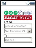
HopStop.com has a full-sized web based service but clearly recognizes that transit users are far more likely to have a cell phone available when they are out on the streets trying to get somewhere. There are actually three different mobile HopStop services. There are two SMS services - both of which require that you register on the HopStop website before using them. Once registered you send an email containing your starting point and destination to HopStop which returns an SMS containing your directions. I suppose cost is the reason an email rather than a short code is used, which is unfortunate, most US users don't even now that they can send email from their phones (and they can't from some some of them). A variant, available only in New York uses an interactive voice recognition system - you tell the system your start and end addresses and the directions are sent to your phone also via SMS. The third HopStop mobile service is web based and requires no registration, just point your mobile browser at www.hopstop.com/pda/ and you ready to plan a trip.
In general, I found web based HopStop Mobile well thought out and quite usable. The interface is simple and intuitive, after selecting a metropolitan area you just fill in free-form From: and To: text boxes and hit the Search button. The address parser is quite smart. It doesn't require "st.", "ave", etc. suffixes and handles address, cross streets , landmarks and business names interchangeably. There are also some options you can choose; there's a dropdown which lets specify that the address is in a specific suburb, you can chose to be routed by rail only, rail plus bus or walking. You can specify the day and time you want to travel, which should default to current time, although in the San Francisco beta, the default is three hours ahead of the current time. Finally you can choose between "More Transfers" and "More Walking". Another great feature is that HopStop supports 10 languages (Chinese, English, French, German, Greek, Italian, Russian, Spanish and Swahili). Only the results are localized not the data entry interface which is always in English.
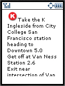
The results consist of turn by turn directions from your current location to the initial station or stop, and then for each transit leg, the name of the bus or rail line and stop to get off or transfer at as well as the approximate travel time. Finally there are turn by turn walking directions from transit to you destination. The text directions are followed by small (120 x 240 px) street maps of each walking leg with the route highlighted.
HopStop puts a 120 x 20 px banner ad at the top of most screens. I think this ad format is perfect for a mobile device, it provides prominent visibility for the ad but don't interfere with using the service. The only problem is that clicking the mobile ad (there only seems to be one, for Zagat) loads a full web page that's not very usable on a phone browser
There were some still some minor beta gotchas with using HopStop. Keep in mind that I did my testing in San Francisco which was just added to HopStop and is clearly labeled as a beta. The other cities are out of beta, but I don't know my way around any of them well enough to do meaningful testing. Anyway here's a few things that still need work.
As I mentioned, the time defaults to the current time in the Eastern Time Zone, three hours later than San Francisco time. You can and should change the time particularly if you traveling in the evening, otherwise you my get routes using the limited after midnight "owl" service long before the regular lines stop running and the owl wakes up. It also doesn't help that the Time: field is at the very bottom of the screen and is a dropdown listing times in half hour increments starting at midnight. That's 48 rows in the dropdown - a lot of scrolling to get to 11PM, for example. Many phones do a lousy job of implementing drop downs (no incremental search or page-down so it takes 46 presses on the down key to get to 11:30 PM). A much better design would be Hour and Minute text fields - entering numbers on a phone keypad is a breeze, particularly if the page forces numeric input with the format="NNNN" or style="-wap-input-format: 'NNNN'" attributes of the text input tag.
HopStop doesn't seem to be aware of the BART rapid transit system, always routing via on the slower, more expensive and more crowded Muni bus and light-rail lines.
There were a few times when I got directions telling me to transfer to a different line in the subway to continue my trip when staying on the original line would have gotten me to my destination just fine with no transfer needed. There was also one particular pair of cross streets that I entered and got a dialog telling me that my exact address wasn't recognized and offering me a list of four similar addresses to choose from. Nothing wrong with that, except that all four alternate addresses were the same and also the same as what I had entered originally!
It also would be nice if HopStop covered more of the San Francisco metropolitan area, currently only San Fransisco, Daly City and South San Francisco are covered. That leaves out significant urban centers like Oakland, Berkeley and the whole Silicon Valley. If the expansion in to Maryland, Long Island and New Jersey is any indication I suspect that HopStop will be eventually expand to cover more of the Bay Area.
Even with the beta warts, HopStop is a already a very useful tool for transit users in any of the covered cities. It displayed beautifully on both my phone's built in Openwave V7 browser and in Opera Mini. Although HopStop's routes were sometimes less than optimal, they were always accurate - following them will get you were you are going.
i-Metro
chotto.free.fr/imetro.html (HTML5)
chotto.free.fr/imetro.wml (wml)

Boston MTBA
mobile.usablenet.com/mt/www.mbta... (xhtml-mp)

OpenMBTA
openmbta.org/mobile (xhtml-mp)

OpenMBTA is a project by developer Daniel Choi and other volunteers whose goal is to promote the use of public transportation by providing free open source transit apps for Boston area residents and travelers. Their first project was a slick location aware iPhone app offering interactactive schedules for Boston's bus, rail and ferry transit services. Most of the iPhone app's functionality was recently ported to the mobile web at openmbta.org/mobile.
The main feature of OpenMBTA is an interactive schedule for all of Boston's transit services. After picking the transit mode (bus, commuter rail, subway or boat) and route from a list you see a table showing the next four scheduled arrival times for each stop on the chosen line. Clicking a stop takes you to a Google map mashup with colored pins. Red pins indicate stops, if a pin is purple it means that a transit vehicle is scheduled to arrive there shortly. Green pins indicate route starting points. OpenMBTA is location enabled, if your browser supports geolocation and you enable it, a blue pin will indicate your location.
OpenMBTA also displays delays and service changes from the MTBA's TAlerts feed and crowd-sourced transit chatter from Twitter's #mbta hashtag. OpenMBTA's next goal is adding real time arrival information to the app and mobile web service.
I discovered OpenMBTA at citygoround.org, which promotes open transit data and features a directory of transit apps and web services.

TLeave (MBTA)
tleave.com/ (xhtml-mp)
Schedules for Boston's MBTA commuter trains optimized for commuters on the go. Pick your start and destination stations and TLeave shows the next departures starting from the current time. Source: City-Go-Round

New Jersey Transit
m.njtransit.com/ (HTML5)
Interactive train and bus schedules for the nation's third largest public transit provider serving New Jersey, New York City and Philadelphia.

NYC Trip Planner
tripplanner.mta.info/mobile/ (xhtml-mp)
An alternate mobile front end to the MTA's New York City Trip Planner. It has the same features and functions as the Trip planner linked from the main MTA mobile page at mta.info but has fewer images and a smaller page size and may work on phones that can't load the regular version.. Source: Tappity

New York MTA
mobile.usablenet.com/mt/mta.info/ (xhtml-mp)
 New York MTA - includes New York's city buses, subway and the Metro North and Long Island Railroad commuter trains. The Metro North schedules are a static list of all trains for a given day of the week and direction, but the Long Island Railroad's allow you to specify the time, start and destination station to receive a custom schedule. For New York city buses and the subways, there is a full featured point to point and round trip planner and a "Service in the Area" feature that list all lines within a mile or less radius of a given address. The site also has service advisories and PDF maps.
iSepta (Philadelphia)
www.isepta.org/m (xhtml-mp)
Easy to use interactive schedule and route planner for Philadelphia's SEPTA regional rail system. Optimized for touch devices like the iPhone, the site is usable on most phones. Source: City-Go-Round

BART - San Francisco
www.bart.gov/wireless/ (xhtml-mp)

iCaltrain
m.icaltrain.com/ (xhtml-mp)
ICaltrain is a mobile timetable webapp for the Caltrain commuter rail system which connects San Francisco with the Silicon Valley, San Jose and Morgan Hill. Source: City-Go-Round

Caltrain QuickPlanner
apps.transitunlimited.org/caltra... (xhtml-mp)
Interactive schedule for Caltrain commuter rail service between San Francisco, San Jose and Gilroy, California.

ba.transportation
www-wireless.usenet-replayer.com... (HTML5)
wap.usenet-replayer.com/data/ba/... (wml)
Mobile access to the ba.transportation usenet newsgroup which covers transportation in the San Francisco (USA) Bay Area

Wheels LAVTA
69.33.224.6/WebWatch/ada.aspx (HTML5)
 WebWatch is part of a product called TransitMaster (TM) from Siemens VDO. I have the opportunity to test WebWatch at the other end of my commute where I ride a bus operated by a suburban transit agency, the Livermore Amador Valley Transit Authority (LAVTA) - better known as Wheels. TransitMaster is a an on board computerized system which provides real-time location information that is used to make automated announcements of upcoming stops and update a bus dispatching system as well as feeding the WebWatch online system. Wheels has implemented WebWatch on all 35 of its routes. The WebWatch map-based interface requires Adobe's free SVG viewer which only seems to work on Internet Explorer and the ancient Netscape 4. There is also a text-based desktop version which should work on most browsers although it's not mobile friendly and requires Javascript. Siemens's site claims that WebWatch supports mobile browsers, but I could not find a true mobile version for either Wheels or another WebWatch system at Chicago's PACE suburban bus system. However both PACE and Wheels have a text-only "ADA" version of WebWatch which works reasonably well on html capable phones as well as on WAP1 phones using the YesWap transcoder. I don't have any experience with the PACE system, but I've been disappointed with Wheels' WebWatch. Frequently it claims "No stops found with upcoming crossings" for all stops on all lines even though there are buses running, and in fact the little bus images still move around on the map. Of course the map isn't available on the ADA/mobile site - only on PC's running IE. Another problem with the system is that the times it shows are sometimes inaccurate. I was waiting at a stop last week and WebWatch claimed the bus was there five minutes before it actually arrived. I don't understand why the text arrival information is wrong as the automated announcements on the buses occur just before the stop as they should and are controlled by the same system. As near as I can tell the moving buses on the map are in the right places too, it's just the text based arrival information that's off - strange. Another issue with Wheels is that while it shows the current time on the screen, the time shown is consistently five minutes fast. In the case where my bus was late, WebWatch said the bus would arrive at 5:54 PM. The bus arrived at 5:59 by my watch which I had set to a NIST time service earlier the same day. By the time the bus arrived, WebWatch claimed it was 6:04
Both Wheels and PACE seem to have implemented WebWatch on all their lines so it has the potential to be really useful if the reliability issues with Wheels at least were resolved.

Los Angeles Metro
m.metro.net/ (xhtml-mp)
Interactive transit trip planner from the Los Angeles County Metropolitan Transportation Authority. Enter your starting and ending points, time and the day of the week. (all fields default to current date and time - nice) and get a recommended routing on public transit. Locations can be entered as address, cross streets or landmarks like "LAX" or "city hall". The planner seems to work well and be easy to use. The LAMTA recommends using Opera Mini to view the site and even provides a download link!

Dallas - DART
m.dart.org/ (xhtml-mp)
Real time arrivals, interactive point to point schedules and rider alerts for the Dallas Area Rapid Transit (DART) system's bus, light rail and commuter rail services.

Miami-Dade Transit
www.miamidade.gov/transit/mobile/ (xhtml-mp)
Miami Florida transit information including realtime arrivals for MetroRail rapid transit and Kendale Cruiser express bus services, Metrobus routes and schedules, elevator and escalators status, fares and service updates.

Denver
www.gortd.com/ (HTML5)
Simple but effective interactive bus schedule for Denver.

Phoenix AZ Valley Metro
m.valleymetro.org/ (xhtml-mp)
Phoenix AZ Valley Metro offers an interactive trip planner, static schedules, service advisories and maps in .gif format. The maps are resized on the fly to fit various mobile screen sizes ranging from 96px to 320 px in width and should load on almost any phone, although they tend to be hard to read in the smaller sizes. There are links to PDF maps too although the ones I tried didn't work. There are also turn by turn text descriptions of each line's route which is probably even more useful than the maps.

Seattle
mybus.org/metrokc/palm.html (HTML5)
mybus.org/wml/ (wml)
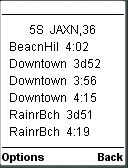
 MyBus is used by Seattle Washington's King County Metro. The system was developed by the Intelligent Transportation Systems Research Program at the University of Washington. MyBus' slogan is "providing travelers with real-time transit information and making transit cool". The MyBus system is quite similar to Portland's Transit Tracker in that it's primary interface uses stop numbers. There is another interface of scrolling lists of bus stops hidden under the Help menu. MyBus' results page conveys quite a bit of information using very little screen real estate. This is visible in the last image. The title "5S, JAXN, 36" means 5th Ave. South at Jackson, Line 36. That's a little cryptic for my taste but I suspect that regular users find it understandable. The rest of the screen lists bus arrivals at that stop by final destination (BeacnHil, Downtown...) and time. The "d" instead of a colon in two of the times indicates that the bus has departed. I can see where if you miss a bus it's useful to know how much you missed it by. This feature would be even more useful if the screen showed the time when MyBus updated the screen. The screen shot doesn't show it but MyBus indicates express buses with an "e" in front of the destination name. If MyBus doesn't have location information for a particular bus, the colon in that trip's times is replaced by an asterisk indicating an estimate. I like MyBus, it is a powerful interface that is quick to use but has a slightly geeky aspect to it that may put off non-technical users. Nowhere is this more evident than if you enter a non existent line or stop number, MyBus responds with a generic 404 error screen, hardly user friendly error reporting. Still I have to give Metro Kings Country and the University of Washington credit for implementing a powerful real-time information system on all lines of this large urban system. Incidentally, MyBus was recently renamed Tracker - although the mobile pages still refer to it as MyBus.
Portland Transit Surfer
tsrf.us/cgi-bin/pda.pl (xhtml-mp)
A lightweight front-end to Trimet's real-time arrival information for Portland's streetcars and buses. Enter a stop number or pick a line and stop from a list to see when the next bus or tram will arrive. Also lists arrivals at nearby stops. Source City-Go-Round
16-Nov-2011 Site is down

myTrimet
mytrimet.com (xhtml-mp)
Ideal for commuters who take the same route every day, myTrimet is an alternate interface to the real time arrival information of Portland Oregon's TriMet bus and rail service, It monitors two stops, one in the morning and one in evening, switching automatically based on the time of day. Best on HVGA screens.

Portland Transit Tracker
pda.trimet.org/ (HTML5)
![]()
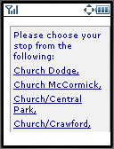
![]() Transit Tracker was developed in house by Portland Oregon's TriMet transit agency. Here is a document (pdf) with which describes the project in considerable detail. Transit Tracker, which covers almost all of TriMet's close to 100 routes, has a WAP1 wml version and a PDA html version that is also usable on WAP2 phones. This is a very nicely implemented mobile site. TriMet's designers obviously were serious about creating a usable site. For one, instead of a long scrolling list of all the stops on a line, like NextBus and WebWatch, Transit Tracker divides the stops into groups (see first image for an example). Instead on 50 stops in a list that is a pain to scroll though on most phones, you first pick the general location of your stop from a short list of ten or so. Next you see another short list of the stops in that area. Another way to specify a stop is by entering a Stop Number. The only problem I see with stop numbers is that you have to find out the number in the first place and then remember it. TriMet provides a number of ways to find stop numbers both on the phone and on the web. To me an ideal place for stop numbers would be on signs at the stops but the TriMet web site doesn't give any indication of this. TriMet is one of the systems that tells you when you bus will come but doesn't show the current time.
Transit Tracker was developed in house by Portland Oregon's TriMet transit agency. Here is a document (pdf) with which describes the project in considerable detail. Transit Tracker, which covers almost all of TriMet's close to 100 routes, has a WAP1 wml version and a PDA html version that is also usable on WAP2 phones. This is a very nicely implemented mobile site. TriMet's designers obviously were serious about creating a usable site. For one, instead of a long scrolling list of all the stops on a line, like NextBus and WebWatch, Transit Tracker divides the stops into groups (see first image for an example). Instead on 50 stops in a list that is a pain to scroll though on most phones, you first pick the general location of your stop from a short list of ten or so. Next you see another short list of the stops in that area. Another way to specify a stop is by entering a Stop Number. The only problem I see with stop numbers is that you have to find out the number in the first place and then remember it. TriMet provides a number of ways to find stop numbers both on the phone and on the web. To me an ideal place for stop numbers would be on signs at the stops but the TriMet web site doesn't give any indication of this. TriMet is one of the systems that tells you when you bus will come but doesn't show the current time.

WMATA
wmata.com/mobile/ (xhtml-mp)
Mobile site of the Washington (DC) Metropolitan Area Transit Authority. Simple but effective trip planner, bus schedules and real-time rail arrival information

Arlington VA
www.commuterpage.com/pocket/pock... (HTML5)
Online transit scheules for Arlington, Fairfax and Falls Church VA and surrounding area.

Circulator (DC) Mobile
circulator.dc.gov/ (xhtml-mp)
Real-time arriaval information for the Circulator bus service in downtown Washington DC. Source: City-Go-Round

TTA Research Triangle NC
tripplanner.gotriangle.org/tpm/ (xhtml-mp)
Trip planner and interactive bus and train timetables for the Triangle Transit Authority which covers North Carolina's Research Triangle region in Durham, Orange and Wake Counties.

Metra Mobile
metrarail.com/metra/wap/en/home.... (xhtml-mp)
Schedules, fare information, maps nearest station finder and travel advisories for Chicago's Metra commuter rail system.

Commuting In Chicago
commuting.in/chicago/newbus (xhtml-mp)
Real time bus arrival information for Chicago Transit Authority (CTA) routes. Allows you to set schedules and preferred bus routes in advance. iPhone optimized site works on most phones. Null "action" form attribute causes it to fail on some feature phones. Source: City Go Round

CTA Mobile
www.transitchicago.com/mobile/ (xhtml-mp)
CTA (Chicago Transit Authority) official site. Schedules, live arrivals, trip planner, fares and maps for Chicoland transit bus and "L" train services.

CTA Train Tracker
www.transitchicago.com/mobile/tr... (xhtml-mp)
The Chicago Transit Authority's new Mobile Train Tracker provides estimated arrival times for "L" trains based on a train's current location and average time between stations.

CTA Bus Tracker
www.ctabustracker.com/bustime/wi... (xhtml-mp)
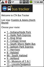
A mobile optimized, text only version of the Chicago Transit Authority's real-time bus tracker. Drill down through the wizard style menus to select your route, direction and bus stop and the tracker will display the estimated wait time for the next bus.
Thanks to the Tracker's 19 KB maximum page size and no JavaScript dependencies it should work with all mobile browsers. Smartphone users may prefer Commuting in Chicago's iPhone obtimized tracker which uses the same data. Source: City-Go-Round

Chicago PACE
gis.pacebus.com/WebWatch/MobileD... (HTML5)
Real-time transit information for Chicago's PACE suburban bus system. Pace uses the same system as LAVTA Wheels (see above). Wheels' implementation has a lot of reliability issues which hopefully don't apply to PACE.

Twin Cities Transit
tctransit.mobi/ (xhtml-mp)
Interactive bus schedules for The Twin Cities (Minneapolis/St. Paul, Minnesota). Looks like an iPhone optimized site but small page sizes and no JavaScript dependencies allow it to work on most phones. Source: City-Go-Round

The Ride - Ann Arbor
mobile.theride.org/ (HTML5)

Toronto TC
m.ttc.ca (xhtml-mp)
The Toronto Transit Commission's official site has bus, subway and streetcar schedules, a transit trip planner, fare and pass information and PDF! maps.

Toronto Next Streetcar
nextstreetcar.ca/ (xhtml-mp)
Built on open transit data from the Toronto Transit Commisson, this webapp gives real time arrival information for Toronto's streetcar lines. Optionally uses the HTML5 geo-loaction API, if available, to display times for the nearest stop. Via @acurrie

Vancouver TransLink
m.translink.ca/ (xhtml-mp)
Schedules for bus, train and ferry service offered by Vancouver, BC's TransLink public transit agency. The site also features the agency's blog. An iPhone version of the site is also available at m.translink.ca/?i

BC Ferries:
mobile.bcferries.com/ (xhtml-mp)
A very slick site from BC Ferries, which provides vehicle and passenger ferry service between the mainland, Vancouver Island and other islands in British Columbia's Gulf of Georgia. It features comprehensive schedules, dockside webcams, vessel tracking and live updates of vehicle load wait times and how full each upcoming departure is. The mobile view was created using Mobify.

Ottawa - OC Transpo
octranspo.mobi (HTML5)
 Ottawa's transit agency, OC Transpo's mobile transit site at octranspo.mobi. The mobile site is being promoted by a prominently placed ad on the agency's full web site that links to a page with a description of the service and instructions for it's use. The instructions seem to be targeted at people who have never used the mobile web. The mobile site itself is intuitive enough that most users should have no trouble using it without having to refer to the instructions.
The site is offered in English and French and has four main functions:
- Travel Planner: Enter start and end points, date and time of day and the planner returns trip instructions including detailed turn by turn walking directions to and from the bus stops. Points can be entered as an address, intersection, bus stop number or by choosing a landmark from a list
- Route Schedules: Enter route number, chose date and approximate time of day, direction and up to three stops from a list to view a schedule.
- Stop Times: Enter bus stop number, chose date and approximate time of day and up to five stops from a list to view all scheduled bus arrivals at that stop. Stop numbers are posted at each stop.
- Fares: Complete list of all OC Transpo fares and passes with prices and restrictions.
 In general I found octranspo.mobi easy to use on a variety of handsets. Page sizes are small which making the site responsive even on slow networks and low end phones. The route planner's walking directions are very clear and detailed.
There are a few areas where minor changes would make the site's already very good usability even better.
- Access keys are used on the home page for one click navigation. I'd like to see them added to the navigation menu at the bottom of each page.
- The Fares section is only linked from the home page of the site, the main menu doesn't have a link to it or back to the home page. Once you drill down into the site, the only way to get to Fares is by pressing "Back" multiple time to reach the home page.
- The site uses tables extensively. Although tables are considered a bit of a no-no in mobile design they actually work quite well on this site - except in the route schedules if more than one stop is chosen which causes a multi column table to be used. On phones with a screen less than 320px wide the table will either wrap or require horizontal scrolling. Listing the times as unformatted text, three across, while not as attractive, would be more usable.
- In the trip planner, intersections have to be entered with an ampersand "&' between the two streets (the online help incorrectly shows a commercial at sign "@" in the example which will not work). I'd like to see " and " excepted as an alternative as it's more intuitive and on many phones it takes fewer keystrokes to type than "&".

London TFL
m.tfl.gov.uk/ (xhtml-mp)
London transit trip planner, live bus depature times and service updates.

NextBuses (U.K.)
mytraveline.mobi/ (xhtml-mp)
Live bus times for public transit buses throughout the U.K.. Enter a street or stop name, postcode, town or area. Matching stops are shown on a map, choosing a stop returns a list of predicted next departure times for all lines serving that stop.

London TubePlanner

Dublin Bus 2 Go!
dublinbus2go.com/ (xhtml-mp)
Dublin Bus 2Go! is a location aware and speech enabled webapp that finds your nearest bus stop in Dublin. It also works using manual input with browsers without geolocation and/or speech support and includes an interactive transit trip planner and DART commuter rail timetables.

WY Metro
www.wymetro.com/.mob (HTML5)
West Yorkshire (England) Metro's real time bus arrival service. They are using a system similar to Barcelona's where you key in the bus route and a stop number which is posted at every stop. The system, which tracks buses using GPS, displays when the next bus will arrive at your stop.

TMB - Barcelona
tmb.net/ibus.html (HTML5)
Real time transit information is something that is a natural for the mobile web. It's huge in Japan where it's often combined with QR Codes for almost instant access. Check out the graphic below from Forrester Research via ZD Net's Russell Shaw to see how it works.

Here in the West, using 2D codes for this purpose is in it's infancy. There's a pilot project in Paris but widespread adoption seems years away. The big thing holding back the use 2D codes on mobile phones is the number of competing incompatible code formats. There are a couple of open, royalty free formats; QR Code and Data Matrix, plus a bunch of proprietary ones like Shotcode, ezCode, Colorcode, BeeTag, Smartpox and Qode. Users won't install a half a dozen different readers on their phones. And until a single format has a dominant market share, phone manufacturers won't make a reader application a standard feature on all phones and transit operators won't invest in the systems and signage needed to make it work.
On my recent trip to Barcelona, I saw a relatively low-tech system for delivering real time transit information to mobiles that's nearly as easy as OR codes and works today with any phone that supports either mobile web or SMS.
Every bus stop in Barcelona has a unique 4 digit number which appears on bus stop signs. The signs also list the line numbers of the buses that stop there. Most of the line numbers have a little mobile phone icon after them indicating that you can get real time arrival information at wap.tmp.net.
To use the service, called iBus, you just enter the 4 digit stop number and the one to three digit line number into a couple of text boxes at tmb.net/ibus.wml (wml) or tmb.net/ibus.html (cHtml). The wml site is actually
 easier to use because it sets your browser's input mode to numeric, saving at least a couple key taps.
TMB (which stands for Transports Metropolitans de Barcelona) is the agency that operates all of Barcelona's transit buses and the Metro. iBus is only one part of TMB's mobile site which also has information on passes and fares, a description of each line with hours of operation and schedule frequency and an interactive door to door trip planner. All these features are available in Catalan, Spanish and English except for iBus which is Catalan only. But iBus is so easy to use that all the Catalan you need to know is that "No. Parada" = stop number and "No. Linia" = line number.
iBus uses GPS technology to track where the next bus is and estimate arrival. It should be accurate but it let me down the two times I tried using it. In both cases it claimed that the next bus would arrive in 20 minutes. The first time I decided I didn't want to wait 20 minutes and started walking only to have the bus pass me less than 5 minutes later! The next time I waited and again the bus arrived within a few minutes. I'm not sure why this happens - perhaps the buses that arrived had broken GPS units and couldn't be tracked. I frequently use the NextBus system in San Francisco (see my review of Nextbus and three other transit trackers ) in San Francisco and find it infallibly accurate. But NextBus' user interface, although recently improved, is still much more cumbersome and time-consuming to use than iBus's simple numeric interface.
In spite of my problems with the information provided by iBus, I think the design of the iBus mobile site is absolutely perfect. It contains no images or irrelevant text so it loads instantly and the all numeric interface is the best possible solution for manual input of location. All such sites should do it this way and several others (Seattle's My Bus and Transit Tracker in Portland Oregon, both covered in last year's review) do.

Network West Midlands
netwm.mobi/ (xhtml-mp)
Real time bus arrival times and maps to help you find your bus stop. Covers the West Midlands (UK) metropolitan area, which includes Birmingham, Dudley, Sandwell, Coventry, Walsall, Solihull and Wolverhampton. Source: Mobility.mobi

Stockholm Arlanda Express
m.arlandaexpress.com/index.jsp?l... (HTML5)
Real Time arrival information for the express train between downtown Stockholm and the city's Arlanda International Airport. The trains travel at 120 mph (200 kph) and the trip takes approximately 20 minutes. The fare is SEK 220 (about $35). The mobile site also has some free train chime ringtone downloads.

Japan - Route Finder
jorudan.co.jp/english/ (HTML5)
 Tokyo and Japan: If you are in Japan or plan to visit there check out the Norikae-Annai (Train Route Finder) from Jorudan (jorudan.co.jp/english). It's an all-inclusive trip planner that not only covers commuter and subway trains in Tokyo but also intercity rail, bus and air connections throughout Japan. For each trip, Jordan will list the fastest route as well as several alternates. For intercity trips over a few hours the first route will be via air, complete with local connections to and from airports. Train Route Finder is an iMode site but seems to work reasonably well with the mobile browsers of most Western phones.
Sydney CityRail
www.cityrail.info/mobile/ (xhtml-mp)

Sydney 131500
mobile.131500.com.au/ (xhtml-mp)
Sydney, Australia ferry and suburban bus schedules.

Melbourne Tramtracker
tramtracker.com/ (xhtml-mp)
Real-time arrival information for Melbourne, Australia Trams

Brisbane Translink

Transitly
www.transitly.com/index.jsp (xhtml-mp)
Transitly is a Touch Web (JavaScript required) interactive schedule for mass transit. Using cookies, It automatically saves your most used routes, and displays them on the front page. Covers Albany, NY; Austin; Chicago; Dallas; Denver; Houston; LA; Milwaukee; Portland, OR; San Diego; San Francisco and Washington D.C. Source: City-Go-Round
30-Jan-2013: Site is down