BeatTheTraffic
beatthetraffic.mobi (HTML5)
 BeatTheTraffic is one of the better traffic US sites I've seen yet on the mobile web at least in terms of number of covered cities and depth of information. It covers about 60 metropolotan areas with traffic maps. a list of estimated travel times and delays for popular trips in each region and a list of current incidents. BeatTheTraffic offers a subscription service ($20/year, one week free trial) that adds SMS or email traffic alerts and the ability to add custom routes and a number of other features. The main downside of this site is that the maps are much larger than they need to be (500px wide and around 85 KB each) which means that they won't load in many mobile browsers.
msTraffic
www.mstraffic.com/mobile/ (HTML5)

Nevada Road Conditions
travelnevada.com/travel-tools/ro... (HTML5)
Nevada road conditions, construction alerts, ski reports and weather forecats from the Nevada Commission on Tourism. Source:dotMobi Blog

MN/DOT
dot.state.mn.us/tmc/trafficinfo/... (HTML5)

NCDOT Mobile
www.ncdot.gov/m/ (xhtml-mp)
The North Carolina Department Of Transportation's new mobile site features real time traffic information including maps and alerts. The site location aware and uses the HTML5 geolocation API. if available to give information relevant to the users location. The site also has Amtrak and ferry schedules and lets travelers search for nearby rest areas.

Seattle
www.wsdot.wa.gov/small/seattle/ (HTML5)
wsdot.wa.gov/traffic/seattle/sma... (wml)
WA DOT Seattle Traffic Washington State DOT has a set of very readable Seattle area traffic maps. Most are 126px wide with one being 256. This site shows that with good mobile specific graphic design it's possible to create a complex map that's highly readable even on the smallest of mobile screens. The site also has travel times and ferry schedules.

ATIS NYC Traffic Cams
service.nyctmc.org/mobile/ (HTML5)
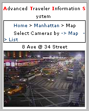 ATIS Mobile comes from from the New York City Department of Transportation (service.nyctmc.org/mobile). There are no maps on this sit, however there is real-time mobile access to 74 traffic cameras scattered around The Big Apple's five boroughs. Images are 167px wide. You can create your own custom bookmarkable page including only the cameras on your favorite routes although it's easy to tay too many and end up with a page that's too big to load on phones with limited memory like the original RAZR V3.
Traffic Cams / Gas Prices
wap.impressglobe.com/ (xhtml-mp)
Collection of Traffic cameras from Australia, Canada, Denmark, Finland, Ireland, Italy, Spain, Sweden, U.K. and the U.S plus gas prices for the Toronto Canada area. Source Oh! Mobile Directory

Long Island, NY
informny.mobi (xhtml-mp)

Traffic.com
mobi.traffic.com (HTML5/wml)
 Traffic.com has a nice new mobile web version of their real-time traffic alert system at mobi.traffic.com. It currently covers 49 US metros. You pick your city from a drop down and then choose a highway from a paged list or click "Hotspots" to see the 10 most congested roads in your metro. Traffic.com uses a nifty and intuitive thermometer graphic to show the relative congestion on each road. You can drill down into a particular highway and see average and slowest speed, delay in minutes and incident reports.
This is the first good, free US mobile traffic site I've seen. The only usability flaw is that the city drop down includes all 49 cities in a long scrolling list. For better mobile usability the city picker should really be divided by groups, (A-F, G-K, etc) of ten or less cities per group. You can avoid the drop down and generally make Trafic.com mobile much more usable by registering on the PC site and setting up "Your Trips" where you can define turn by turn routes. Then when you log in to the mobile site you can go to your trips and see the current conditions of each segment of your trip.

TFL Traffic Alerts
mobile.twitter.com/tfltrafficnews (HTML5)
 Transport For London's Traffic Map was at trafficalerts.tfl.gov.uk/pda. It was one of the most full featured of all traffic sites, although as implied by the "pda" in the URL, this site was designed for high end devices with large touchscreens. The maps are 240px wide and an image map on the main page enables touchscreen navigation. You can also search for a street or road by name. As you can see by the image, the maps are very detailed and high quality. They are zoomable and scrollable and there are options to show an aerial photo overlay and/or congestion indicators at locations of roadwork or accidents. You can also toggle the display of camera icons on the maps. Clicking a camera shows the camera's traffic view.
6-Mar-2013: The Transport for London mobile site has been redesigned and traffic maps seem to have gotten lost in the redesign although they are still available on the desktop site at: www.tfl.gov.uk/roadusers/ Mobile users can follow @tfltrafficnews on Twitter for traffic alerts and updates

RAC (UK)
rac.mobi (xhtml-mp)
The Royal Auto Club provides members with car insurance and both non-members and members with roadside assistance. The RAC's mobile site offers very good UK driving directions with maps plus traffic alerts and click to call links to summon a breakdown lorry (tow truck) or report an accident if you have RAC insurance. Source Mobility.mobi

Traffic Scotland
trafficscotland.org/pda/ (HTML5)
Traffic alerts, scheduled closures and roadwork, weather and live cameras for motorways around Scotland. The camera images are rather large for typical mobiles at 320x240px although perfect for the new smartphones with querty keyboards and landscape screens like the Nokia E61 and T-Mobile Dash (HTC Excalibur). There's a wml version of this site minus the cameras at trafficscotland.org/wap

roadreport (UK)
roadreport.mobi (xhtml-mp)

Houston Transtar
traffic.houstontranstar.org/mobi... (HTML5)
Houston's Transtar has mobile traffic maps that are very readable. The map pages are served in wml or html based on browser detection but at 180-220px wide the maps are too large for many phones. The site also has traffic cameras, travel times and listings of highway construction and accidents.

SF Bay Area Traffic
map511.atspace.com/ (HTML5)
 San Francisco Bay Area Traffic Maps: (map511.atspace.com) Real time traffic maps for the San Francisco area. There's an overview map and detailed maps of the East and South Bay, but not for San Francisco, the Peninsula or Marin which have plenty of traffic too. The maps are "optimized for Palm Treo 650 and 700p mobile devices" so they are a big 306px wide and backed by an html image map so that touch screen users can tap on the overview map to open a detailed sector map. There are also text links to the sector maps so the site is usable on any phone that can display images that large. Opera Mini however gets confused by the image map and breaks the single image into three separate images arranged in a geographically illogical order.
Trapster
trapster.com/m/ (HTML5)
 Trapster offers this mobile site which displays the location of policespeed traps, red light and speed cameras and places where traffic officers are hiding. You just enter a zip code or address to see the traps, either as a list or on a Google Mobile Map. The data comes from registered users of Trapster's free Java, S60 3rd Edition or Windows Mobile 5 and 6 applications which let you report a trap with a single key press using location data from the phone's GPS. The application also gives real time alerts when you drive into an area with a trap. If you don't have a compatible phone you can report traps by toll-free number, SMS or by using Jott's voice recognition technology Via: The Phoneboy Blog
6-Mar-2013: Trapster's mobile site now requires a login and the link to search for traps and display trap maps returns an error