The US government makes an enormous amount of data available for free as downloadable XML files and through Web based APIs . There’s a comprehensive listing of government data sources and tips for using them at usgovxml.com. Many of these data sources could easily be turned into useful web and mobile web services.
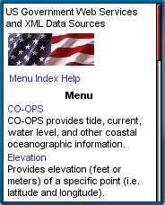
USGovXML.com has created a collection of sample mobile mashups using a small subset of the available US government data services at usgovxml.com/mobile. There’s a huge amount of information available on that site which includes the following mobile lookups.
- Gazetteer: A geographic dictionary that provides latitude and longitude information for many places throughout the U.S..
- Proximity: Find the distance to the nearest wetland with map.
- Elevation: Provides the elevation of a particular point and a map.
- Station: Shows water quality monitoring stations within a geographic area on a map.
- CO-OPS: Tide, current, water level and other coastal oceanographic information.
- NDFD: Extremely detailed weather forecast data from the National Weather Service’s digital forecast database.
- UV Index: Predicts the next day’s ultraviolet radiation levels.
- Web Tools: Zip code lookup, address verification and the determination of which city is in a particular zip code.
- SBSS: Returns a firm’s 8(a), HUB Zone and SDB certification status from the Small Business Administration’s database.
The site is optimized for Mobile Internet Explorer but is usable in other full-web mobile web browsers including Opera Mobile and Mini, Webkit and Safari.
Filed in: Wap Review Directory – Reference
Ratings: Content: ![]()
![]()
![]()
![]()
![]() Usability:
Usability: ![]()
![]()
![]()
![]()
![]()
Ready.mobi Score: 3 “Fair”
Mobile Link: usgovxml.com/mobile